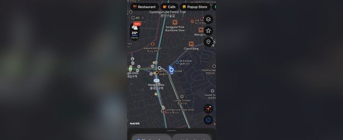
You land in Seoul, drop your bags at the hotel, and open Google Maps to walk to a coffee shop three blocks away. You type it in, tap directions, choose “Walk” — and there’s no route. No blue line. Maybe a “can’t find a way there” message. You try driving directions for tomorrow’s day trip and get the same nothing. The app that runs the rest of your travel life just… stops working in Korea.
You didn’t break anything. Google Maps genuinely can’t give walking or driving directions in South Korea, and it’s not a glitch you can fix.
The good news: locals don’t use it either. They use Naver Map — in fact, when a Korean is heading somewhere they don’t know, or just wants to check whether a restaurant is open, Naver Map is the first thing they reach for too. Learn this one app and you can get just about anywhere in the country. Here’s how, the way a local friend would walk you through it.
Why Google Maps doesn’t work in Korea
This catches almost every first-timer, so it’s worth thirty seconds to understand.
For national-security reasons — Korea is technically still at war with the North — a Korean law keeps detailed, survey-grade map data from being stored on servers outside the country. Google runs its maps on overseas servers, so for years it was never given the high-precision data that local apps use. What you actually feel: Google Maps in Korea can search for places and handle subway directions, but it can’t give you reliable bus, driving, or walking navigation.
“But I read Google Maps works in Korea now!” — here’s the part the headlines get wrong. In February 2026, after a 19-year standoff, Korea conditionally approved letting Google export the detailed map data.
That sounds like the problem is solved. It isn’t — not yet. As of July 2026 the deal has stalled: Google and the government still haven’t agreed on the conditions, and nothing has actually changed inside the app. Walking and driving directions still don’t work. So for any trip you’re taking now, treat Google Maps as “search only” and use Naver to get around. (It’s worth re-checking when you travel — this may finally change — but don’t count on it.)
Step 1: Download Naver Map before you go
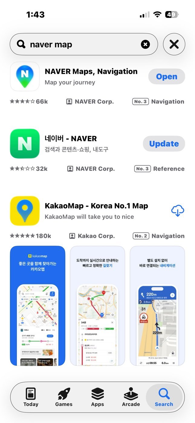
Naver Map (look for the green “N” icon) is free, and you can download it from your normal App Store or Google Play — you do not need to switch your Apple ID to Korea. It’s right there in the US, Japanese, and other countries’ stores, listed as “NAVER Maps, Navigation.” Grab it before your flight so it’s ready the moment you land — and line up mobile data too (a Korean eSIM or pocket Wi-Fi), because these apps need a connection to do anything.
One more app worth installing: Kakao T — Korea’s main taxi-hailing app (more on that below). It’s free, and it’s the easy way to catch a cab without speaking Korean. Sign up before you fly, though — verifying a non-Korean phone number can be slow.
You don’t need a Naver account, and you don’t need a Korean phone number. If the app ever shows a login screen, just tap Skip — all the navigation works in guest mode. You’d only log in if you want to save favorite places.
Step 2: Switch it to English
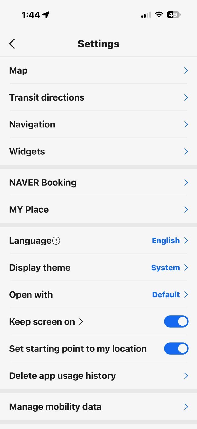
Naver Map opens in Korean, but it has a full English mode — menus, buttons, and even the spoken turn-by-turn navigation:
- Tap the menu icon (three lines, ☰).
- Open Settings (the gear icon).
- Tap Language → English.
That’s it. Under a minute, and you only do it once.
Step 3: The one trick — search in Korean, not English
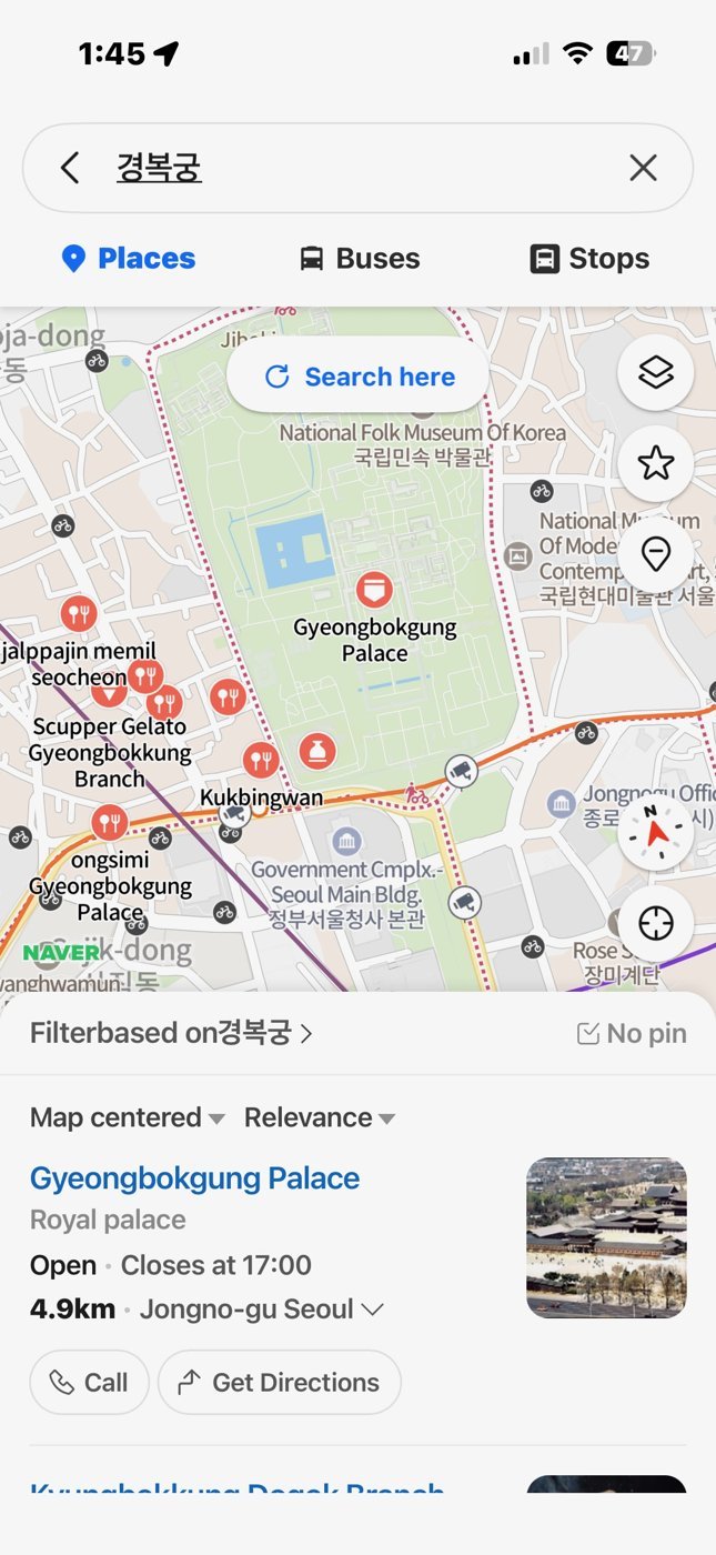
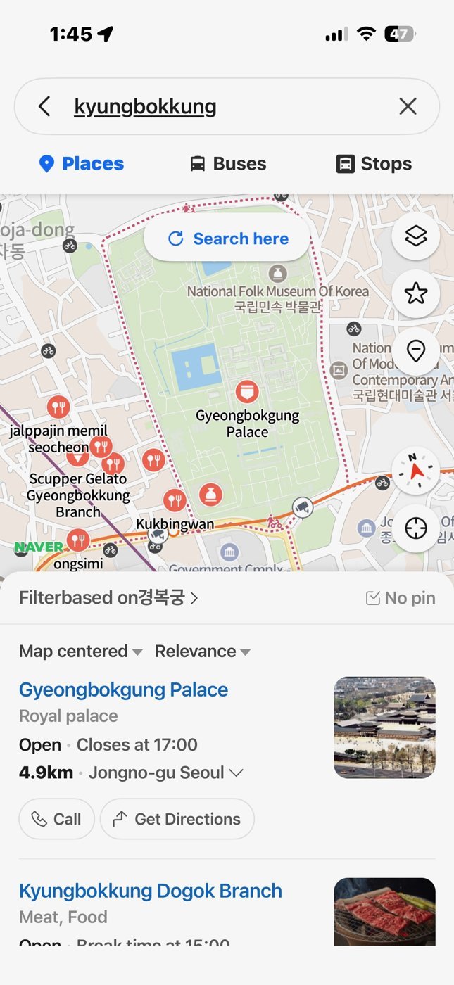
This is the single thing that trips people up, so I’ll be blunt about it: for smaller places, Naver Map works far better when you search in Korean than in English. Big sights like Gyeongbokgung Palace are fine typed in English. But that neighborhood cafe or local restaurant you saw on Instagram? Type its English name and Naver might show nothing — even though it’s right around the corner. That’s not you doing it wrong; it’s just how the app’s search is built.
Three easy ways around it:
- Copy-paste the Korean name. Most cafes, restaurants, and shops list their Korean name on Instagram, their own website, or a blog. Copy it, paste it into Naver’s search bar, and it pins instantly. This is the highest-hit-rate move.
- Paste the phone number. Have a Korean phone number for the place? Paste it into the search bar and it drops a pin directly.
- Paste the Korean road address. For big landmarks the road address (도로명 주소) works great — for example, searching
서울 종로구 사직로 161lands you right on Gyeongbokgung Palace.
A handy habit: the night before, look up where you’re going, find the Korean name or address, and paste it in. Save yourself the standing-on-a-corner-squinting-at-your-phone moment.
Step 4: Get directions
Once you’ve found your place:
- Tap its pin, then tap the directions button — the one with the little route/arrow icon (in Korean 길찾기; in English mode it usually reads Directions).
- Naver fills in My location as your starting point automatically. If your GPS is off, set the start manually.
- Pick the tab you want: transit (bus + subway), car, or walk.
For getting around a city, transit is what you’ll live on — and it’s where Naver leaves Google in the dust. (You’ll pay for those rides with a T-money card — grab one early.)
Step 5: Read the transit results like a local
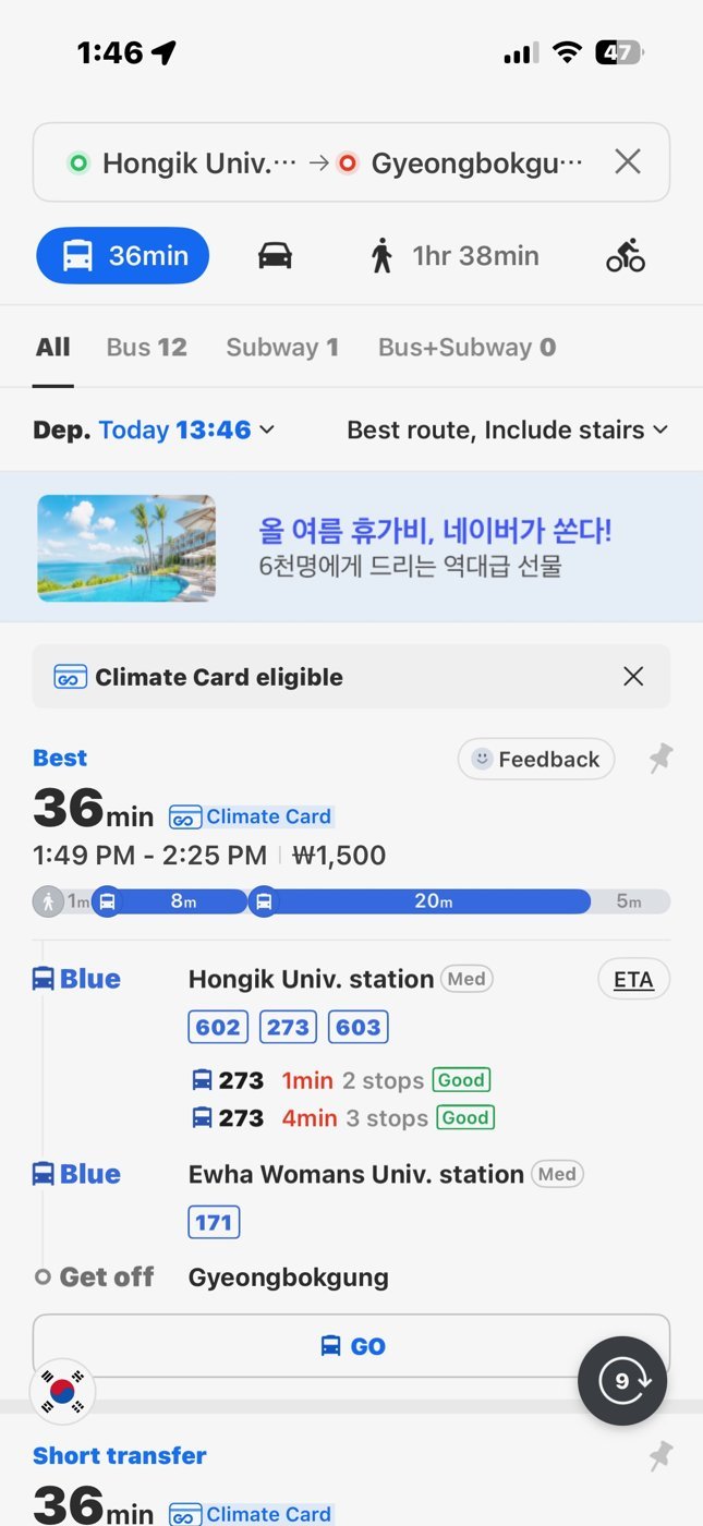
Naver’s transit directions are the best part, once you know what you’re reading:
- It names the exact subway exit number. This matters more than you’d think — big Seoul stations have 10 to 20 exits spread hundreds of meters apart. Take the one Naver names. The wrong exit can mean a 15-minute detour and a very confusing walk.
- It tells you which way the train is going (“bound for ___”), so you wait on the right platform.
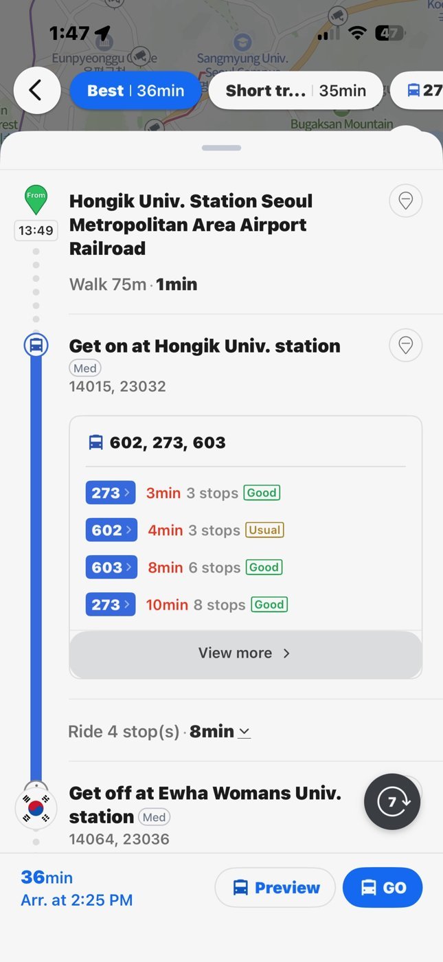
- For buses, it shows real-time arrivals — minutes until the next bus, where to board, and a “get off now” nudge as your stop approaches. This live bus info is exactly what Google Maps can’t reliably do in Korea.
Follow the exit number and the bound-for station, and you’ll move through the subway like you’ve done it for years.
Looking up subways and buses
Sometimes you don’t want a full point-to-point route — you just want to look at the subway map, or check when the next bus is actually coming. Naver does both, and well.
Subway routes and stations
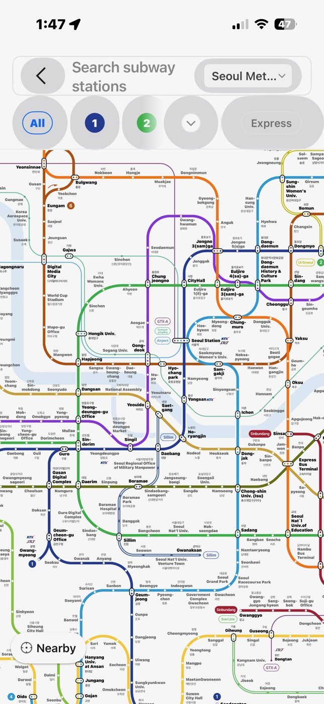
Naver covers every subway system in Korea — Seoul, Busan, Daegu, and the rest. The classic colour-coded subway line map is built right in, and looking up stations and planning rides works beautifully. Search a station by name, or tap one on the map, and from there:
- Tap any station to see its line(s), the last-train time (so you don’t get stranded after a late night), and the station’s exits.
- Tap a start station, then a destination station, and Naver lays out the ride: how long it takes, how many stops, and where to transfer. It even tells you which car to board — shown as something like “5-3” (car 5, door 3) — so you stop right by the transfer stairs or your exit.
- Lines are color-coded to match the signs inside the stations, so “follow the orange line (Line 3)” lines up with what’s on the wall.
When is my bus coming?
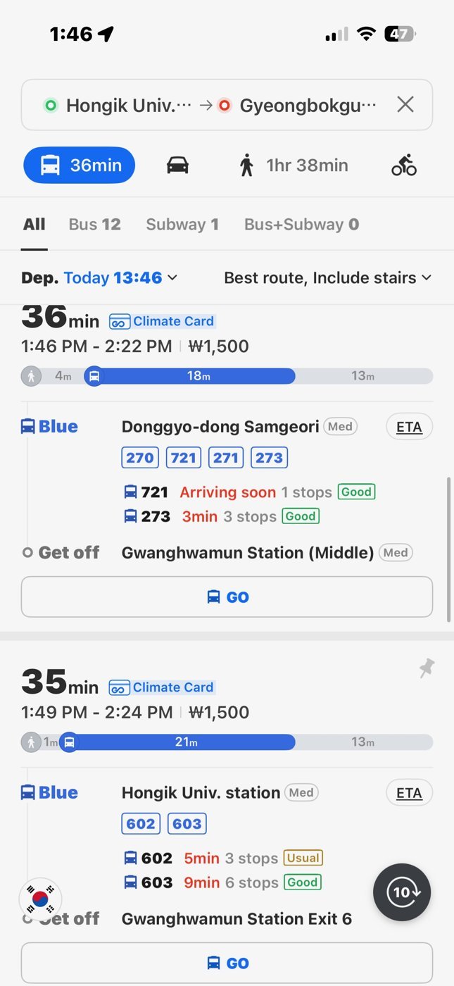
This is the one that saves you standing at the curb guessing. Naver gives you live bus information two ways:
- Tap the bus stop on the map. Zoom in until the little bus-stop icons appear, then tap the one you’re standing at (glance at the stop name on the physical sign — nearby stops can share a name). Naver lists every route that stops there with a live countdown: “arriving in 3 min,” “2 stops away.” No more wondering whether you just missed it.
- Search the bus number. Type the number into the search bar and Naver shows that bus’s entire route, stop by stop, with the live arrival times along it — handy for working out which direction you need and which side of the road to wait on.
That live, stop-by-stop view is one of the biggest reasons to keep Naver open.
Checking out a place before you go
Naver Map isn’t just for directions — it’s how Koreans decide where to go in the first place. Tap any place, or search it, and its info card tells you almost everything you’d want to know:
- Is it open right now? The card shows opening hours and a live Open / Closed status, plus any break time — so you don’t walk 15 minutes to a restaurant that’s closed between lunch and dinner. (Many Korean places do shut for a few afternoon hours, so this saves you a wasted walk.)
- Menu and prices. Lots of places list their menu with prices and dish photos — useful when you can’t read the sign out front.
- Photos. Real customer photos of the food, the storefront, and the inside, so you know what you’re walking into.
- Reviews. This is where Naver really earns its keep — a huge volume of reviews, many tied to a verified receipt (the reviewer had to prove they actually showed up), which makes them much harder to fake than the paid blog posts that clutter Korean search results. They’re in Korean; point Google Translate’s camera at the screen to get the gist.
- One-tap directions. Hit Directions straight from the card and you’re routed there.
A good habit: before you head out, search the place, glance at the hours and a couple of photos, and confirm it’s open. It’s the same 20-second check a local does without thinking.
Naver vs Kakao: keep it simple
Use Naver Map as your one main app. Beyond having the strongest English support, here’s why locals pick it over Kakao Map for everyday use: nearly every Korean and nearly every business is on Naver, so its listings — opening hours, menus, whether a place has quietly shut down — tend to be the most complete and the fastest to update, and it carries far more reviews and photos.
When you need to know whether a restaurant is actually good, or even still open, Naver is where the answer lives. For getting around, you really don’t need a second map app.
The one thing Naver can’t do is hail a taxi. For that, install Kakao T — a separate app from Kakao Map, and Korea’s dominant cab-hailing service. You set your pickup and destination on the map and it sends the nearest driver.
One heads-up: foreign cards sometimes won’t register for in-app payment — if yours won’t go through, just take the ride and pay the driver at the end with cash or T-money. If you’d rather pay by card, Uber also runs in Korea (it books licensed local taxis) and takes foreign cards right in the app.
(Subway power-users sometimes add a dedicated app like Subway Korea for which-car-to-board transfer tips — but you really don’t need it. Naver’s directions are plenty.)
A few things to know
- You need mobile data. Naver lets you pre-download map areas for offline viewing (in the menu under Offline Maps), but search, routing, and live transit still need a connection. So line up an eSIM, SIM, or pocket Wi-Fi and you’re covered from the airport.
- Your location dot can drift. In dense high-rise areas or underground, your blue dot may sit slightly off or wander a bit. Cross-check against a visible landmark or an exit sign.
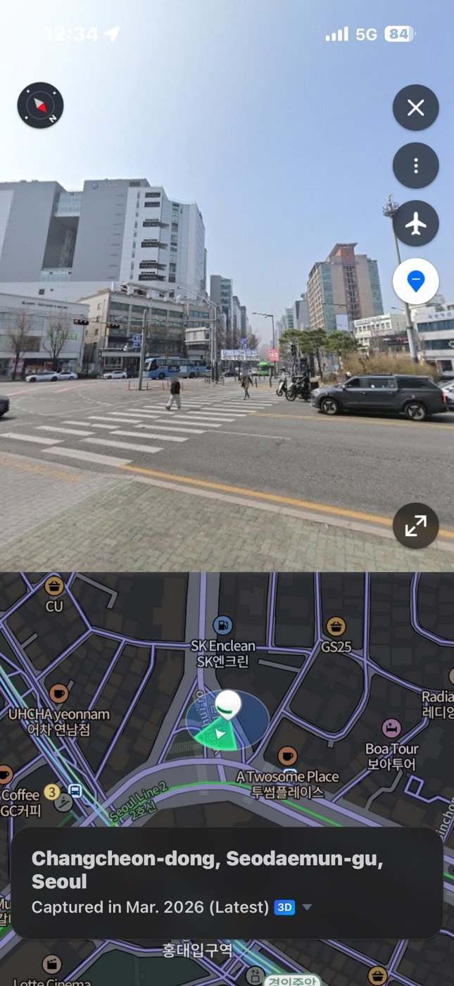
- Turned around at a subway exit? Use Street View. Big exits spit you onto the street facing who-knows-where, and the blue dot doesn’t always help. Turn on Naver’s 거리뷰 (its Street View) — tap the road-view/layers control on the right edge of the map and pick 거리뷰. Streets that have street-level photos turn blue; tap the blue street nearest you to open a photo of that spot, then rotate it to match the shops and signs in front of you. Now which way to walk is obvious. It’s the reliable fallback when GPS drifts between tall buildings, because you’re matching real signs rather than trusting the sensor. (One naming quirk: “Road View” is actually KakaoMap’s term — in Naver Map, look for 거리뷰.)
- Reviews are in Korean. Naver has fantastic, photo-heavy, receipt-verified reviews — but they’re in Korean. Use a translation app (Papago or Google Translate) — pointing Google Translate’s camera at your screen is the quickest way to read them.
Pair Naver Map with a T-money card for the buses and subways, and you’ve got the two things that actually move you around Korea.
FAQ
Does Google Maps work at all in Korea?
Partly. It’s fine for searching places and reading reviews, and subway directions mostly work. But it can’t give reliable bus, driving, or walking directions — that’s the dealbreaker. Use Naver (or Kakao) to actually get around. The February 2026 “approval” you may have read about hasn’t taken effect yet.
Do I need a Korean phone number or a Naver account?
No. Naver Map’s navigation is free and works in guest mode — tap Skip past any login. You’d only sign in to save favorite places.
Can I download Naver Map with my US (or other) Apple ID?
Yes. It’s in the US, Japanese, and other countries’ App Stores as “NAVER Maps, Navigation,” and on Google Play everywhere. You don’t need to change your Apple ID region.
Why can’t Naver find my restaurant when I search in English?
Naver’s search works far better in Korean. Paste the place’s Korean name, its phone number, or its Korean road address instead — any of those will pin it.
Do I need Kakao Map too, or just Naver?
Just Naver Map for getting around — it’s the stronger app for foreigners. The Kakao app you actually want is Kakao T, a separate app for hailing taxis. So: Naver Map to navigate, Kakao T to catch a cab.
How do I see when the next bus is coming?
Tap your bus stop on the Naver Map — it lists every route that stops there with a live countdown (“arriving in 3 min,” “2 stops away”). You can also search the bus number to see its full route and the live arrival times along it.
How can I tell if a restaurant is open?
Search the place in Naver Map and check its info card — it shows opening hours, a live open/closed status, and any afternoon break time. Many Korean restaurants close for a few hours between lunch and dinner, so it’s worth a quick look before you go.
Can I use Naver Map offline?
Not really — it needs data for live transit and routing. Get an eSIM or pocket Wi-Fi so you’re connected from the moment you land.
Read next: give the app its first real job — navigate to Gwangjang Market for lunch — and for the trips walking can’t cover, here’s how Kakao T works.